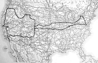
June 13, 1924
Worland, Wyoming to Cody, Wyoming
95 miles
I left Worland early and got in to Cody about 10 a.m. where I found out that I could not get into Yellowstone Park until the June 15th [opening], so I took my motorcycle to a blacksmith and had him straighten the front fork. Cody is a town of about 1,200 people. They are going to unveil the monument of Buffalo Bill (William F. Cody) here July 4 and also have a real Western Stampede. I saw a little rough riding and roping today on their tryouts. I covered 95 miles today and I bought my supplies for my trip into the Park.
June 14, 1924
Cody, Wyoming to Yellowstone Park, Wyoming
Camp Yellowstone Lake altitude 7,800 feet
90 miles
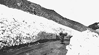
I left Cody early and arrived in Yellowstone Park about 9:30 a.m. and went right in. The road from Cody is through Shoshone Canyon which rises from 1,200 to 1500 feet above the river in the bottom. The road runs along the river in some places and on top of the canyon in some places. There is a dam in the canyon that dams up the Shoshone River in the middle of the canyon. The dam is 328 feet high and 200 feet wide and cost $1,354,000 to build. The dam irrigates 300,000 square miles. The water is backed up for about 15 miles. From the entrance to the Park to Yellowstone Lake (the camping ground [where] I am staying in tonight) is all uphill. The road is just wide enough in most places for one car to pass with turnouts to pass cars going in the opposite direction. I passed through a mountain pass with snow on each side about 5 feet [deep]. It is a beautiful drive up here.
June 15, 1924
Yellowstone Park
201 miles
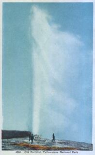
I left my camp at the north end of Yellowstone Lake early and started out to see the Park. The road followed the Yellowstone River all the way to Canyon Junction. At Canyon Junction the Yellowstone Falls and canyon are located. The falls are 109 feet. There are several small falls before the big one. From Canton Junction I went to Norris Junction. At Norris Junction the Norris Geyser and Norris Basin are located. From Norris Junction to Madison Junction the road follows the Gibson River. There is very pretty scenery on this road and also the Gibson River Falls which are 80 feet high. From Madison Junction I went on the road to Old Faithful. The road follows the Firehole River through the Lower Geyser Basin, The Mammoth Paint Pots, Firehole Lake and the Upper Geyser Basin. The Old Faithful Geyser has an altitude of 7,337 feet and throws water to a height of 165 feet every 55 minutes. I took 3 pictures of it. The water stayed up about 2 minutes. Leaving Old Faithful I went back to the road to Madison Junction. I took pictures of the Grant Geyser, the Grotto Geyser, and the Morning Glory. From Madison Junction I went to the road to the West entrance to the Park. The road follows the Madison River. As a whole Yellowstone Park is a wonderful place. From the Park I started on the road toward Pocatello, Idaho. I camped on the Warm River at Warm River. The tourists of 12 states camped there gathered around a large campfire and told stories and sang songs until 1:00 a.m. It was some day.
June 16, 1924
Warm River, Idaho to Black Foot, Idaho
94 miles
I left camp at Warm River about 10 a.m. and had rough going over loose gravel and sand. I took two spills in ruts but did not hurt me much. I am about over the Rockies and on the Plains. I am staying at a Hotel here in Black Foot, Idaho. Arrived here 2 p.m. They had a Western rodeo and horse racing celebrating Pioneer's Day.
June 17, 1924
Black Foot, Idaho to Filer, Idaho
164 miles
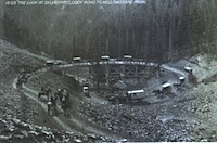
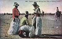
I left Black Foot about 11 a.m. The roads were hard but had loose gravel and stone on them, making it hard to ride in places. I took the State Highway by way of Pocatello, American Falls, Delco, Burley, and Twin Falls. I went across the suspension bridge across the Snake River which they say is the highest suspension bridge in the world. It is 10 miles east of Twin Falls. I covered 164 miles across the Desert of Idaho today. It is the northern end of the Great American Desert. In places there was stretches of 40 to 50 miles with not even a house. I'll get the rest of the desert tomorrow on my way to Boise, Idaho. I camped in a barn. Typical cowboys waiting their turn at the bucking contest
June 18, 1924
Filer, Idaho to Boise, Idaho
158 miles
I left Filer, Idaho about 10 a.m. on fairly good roads. It has been cloudy all day and several times I got caught in little showers. They say it is the first time it has rained here in two months. All the road today was over dirt except where they irrigate the land. I am now in the Blue Mountains. They have a suitable name because they have a bluish look for miles around. I am staying at the Y.M.C.A. here tonight. They have a fine place here. I am going to wrestle in the Gym tonight. I covered 158 miles today.
June 19, 1924
Boise, Idaho to Baker, Oregon
150 miles
I left the Y.M.C.A. at Boise about 1:30 p.m. and started west on the Old Oregon Trail. The road was gravel and very good. I covered the last 51 miles in 1 hour and 12 minutes over gravel mountain roads. Motor runs better than ever. Everything O.K. so far and staying at the Y. here. I am now traveling on Pacific time.